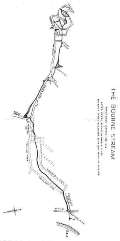
Our town has its origins in a settlement which in Anglo-Saxon times was known as Burne, meaning a brook or stream. This name became Borne in Norman times and later Bourn or Bourne. About the end of the 13th Century the prefix Est was added and Estburne and Estborne are recorded. It is believed that this was done to distinguish the Borne at this end of the County from the one at the other end which became known as Westbourne. The name Bourne continued to be used occasionally up to comparatively recent times.
The stream from which our town is named has been known for very many years as the Bourne Stream and though some people may argue that the word Stream is superfluous, the writer prefers to use both words.
The early settlers needed to make their homes where there was a constant supply of water and that is why so many ancient villages are to be found at the foot of the Downs where there were springs issuing from the chalk. The settlement of Burne is a good example, the water supply being the springs in the area of the present Motcombe Gardens. From early times there was a pond in this area filled by the springs, the overflow constituting the source of the Bourne Stream. The pond at one time covered most of the low lying ground of what we now know as Motcombe Gardens. On the west side was a range of buildings serving Motcombe Farm, one of which still survives, and the farm yard came down to the edge of the pond. The Dovecot which remains would also have been on the edge of the pond. Nearby was a withy bed from which local basket makers obtained their material. Up to the middle of the last Century the pond was open to the farm road on the north side and local inhabitants drew water from this supply. It was owing to this Public use that regulations were made to prevent fouling of the water, and it is on record that in one case a man was fined for driving his pigs into the pond. At the east end of the Gardens, beside the Bowling Green, is an old wall with a loop hole, splayed on the pond side. It is thought that this was used to shoot wild duck on or over the pond.
In 1857 the pond was altered to be more in keeping with its use as a source of water which might be used for drinking. The sides were filled in and the area much reduced in size, while bricks were used to line the side This made the pond square in shape and much as we see it today. About the same time the pond was fenced off from the road and a pump and trough installed at the roadside enabling local residents to continue drawing water from this source. Two years later the Eastbourne Waterworks Company was formed and pipes were laid from the pond to the Seaside Road end of Susans Road, where water was pumped into a raised reservoir for distribution to the adjoining rapidly expanding part of the town.
The course of the Bourne Stream, where it leaves the pond still may be seen for some yards before. passing underground below the Bowling Green and Lawns Avenue. Up to the early part of this Century it passed as an open stream through the grounds of a large house in Ocklynge Road known as "The Lawn" where it fed a large pond. At one time the stream then passed alongside a house which for many years was used as Eastbourne's only Post Office and it then flowed across Ocklynge Road as an open stream. There it was crossed by a footbridge with room for wheeled traffic on either side.. Early in the last century the stream was enclosed in a culvert under the road. After that the stream passed into the grounds of a brewery which had been established in 1777 and was later to become the Star Brewery. No doubt in its early days the waters of the stream were used by the brewery. In about 1875 a culvert was made to carry the stream through the brewery and after that it passed across the junction of Baker's Road and Star Road where it often overflowed forming a muddy pool known as "Puddledock". Latterly, it then passed under the pavement on the south side of Star Road for a few yards before passing inside the wall of the last house in Spring Terrace (demolished in 1973). The stream was open here until it was covered by concrete slabs in more recent years.
in 1974 the stream was diverted through a large pipe from the west side of Ocklynge Road, around the edge of the Star Brewery site, to rejoin the old brick built culvert at the bottom end of Spring Terrace. From here the open stream formerly passed in front of the Court House, but when Moat Croft Road was constructed, it had to be taken underground, to re-appear at the tear of houses in the Goffs. The open stream still flows through the gardens of those houses through a channel which was raised above the level of the original stream in order to provide a head of water for a mill pond. There is a public footpath between Nos. 46 and 48 and anyone tall enough can look over the wall of No. 48 and see the brick lined channel with the Bourne Stream running through it. A dip in this footpath shows where the original stream must have run. This path also appears to mark the western boundary of the Mill Pond as the garden of No. 46 is at a much lower level than the path. This same path passes between two flint built walls which were obviously at one time part of a building, but it is a matter for conjecture as to whether it was used in connection with the stream.
The Mill Pond was three quarters of an acre in extent and stretched from the path just mentioned to the back of the old Drill Hall and it widened out at that end to cover much of the garden at the rear of the house in Upperton Road, until 1974, part of the Holy Rosary Convent School. The pond was surrounded by trees and was one of Eastbourne's beauty spots. The public appear to have had access to it and were able to skate there when the pond was frozen over. A figure of Neptune in lead which formerly stood at the edge of the pond has been moved to Motcombe Gardens at the edge of the pond there.
The Mill stood near to where the house, (formerly known as 'Bourneside') at the rear of the Drill Hall, now stands. According to some reports, parts of the mill buildings were incorporated in the house, but a careful examination has provided no evidence of this. The last use of the mill was as a Pulling-mill for wool. When the pond was drained, the Bourne Stream waters were taken in a culvert under the garden of the house. Beyond this
point the stream continues to pass underground but not completely out of sight. The house at the bottom of the Goffs had additional buildings added to it in the early part of this century for use as a dairy, and until not so long ago the stream could be seen flowing through an open channel in the dairy yard. The dairy has ceased to operate and the stream has been covered with concrete slabs, but The course of the stream can still be identified and in fact, where one of the slabs has been broken, the last of the Bourne Stream could (in I975) be seen before it finally vanished underground.
Before the town really began to develop, following the coming of the railway in 1849, the Stream continued in the open until it reached the sea. From the bottom of the Goffs the stream flowed alongside the road which was known as Water, Watery or Watering Lane. It continued to be known by one or other of thse names until after the houses on the south side were built, when the residents asked that the name be altered to Southfields Road. The stream frequently overflowed, turning the lane into a sea of mud, with a result that the stage coaches and other wheeled traffic wishing to proceed between Old Town and South Street preferred to use Borough Lane, Compton Place Road and Meads Road, notwithstanding the climb involved, rather than risk getting stuck in Water Lane. At some time an artificial channel was made for the stream at the southern end of the lane, at a higher level than the original course and a long pond was created, stretching back from Grove Road across what is now Old Orchard Road. Records of two or three hundred years mention another watermill on the Bourne Stream and it seems that a head of water necessary to work a mill could have been provided by this pond. It was generally known as The Sheepwash and was no doubt at some time used for this purpose. 250 years ago it was being used as a fish pond to provide fish for eating.
Towards the end of the last century the pond was much reduced in size and had the Village Pound on the east side and the Vestry room on the west. On the Old Orchard side there was a wall with an arched opening to
let the water through. The Grove Road side remained open for public use for many years but eventually a wall was built on that side, over which the pond could still be seen until it was drained in order that a Fire Station could be built on the site. After the Fire Station and the Technical Institute had been destroyed by enemy action, the present building which houses the Borough Treasurer's and other offices was erected on the site of the pond. From that point the stream crossed in front of Hartfield Farmhouse, which, after the railway opened in 1849, became an inn under the name of the Gilbert Arms, but more commonly known as The Squirrel, this being the animal appearing as the crest of the Arms at the Gilbert family. Subsequently the name was changed to The Terminus Hotel.
After passing in front of The Squirrel Inn, the site of which is now occupied by the shops from Ivy Terrace round to Terminus Road, the stream flowed along what is now Sutton Road, There was another waterway or ditch branching off from the main stream, passing alongside what is now Ivy Terrace, and then along the southwest side of the present Terminus Road. This has sometimes been erroneously referred to as the Bourne Stream. It later rejoined the main stream as the latter passed along a line between Tideswell Road and Langney Road. By this time the stream had reached the marshes and a number of interconnected ditches joined it on the north side. The course of the stream must have decided the line of Langney Road and latar when Tideswell, Longstone and Ashford Roads came to he constructed, the stream must have influenced their layout also. On reaching the present line of Bourne Street opposite The Rose and Crown public house the stream turned towards the sea and passe alongside a track called Cowbrook Drove which was used moving cattle between the marshy meadows and the road to Pevensey (now Seaside). Cowbrook Drove later became know as Marine Drove and is now part off Langney Road. Where that road now meets Seaside, was formerly a large pond known as Broadbourne which was formed by the Bourne Stream being dammed by the shingle bank. In order to keep this pond to a reasonable size so as not to impede wheeled traffic, a cutting was made into the shingle bank to help the water find its way through the bank into the sea. There was insufficient flow of water for the stream to maintain an open mouth to the sea.
To return to present days, the stream waters are now carried underground from the bottom of The Goffs along Southfields Road to the railway station and from there south of the railway until the waters re-appear in the open drainage channel which runs at the rear of houses in Moy Avenue. From there the water mingles with other drainage water from the marshes, most of which eventually finds its way under the Tollgate Bridge in Seaside, to Princes Park Lake and from there into the sea.
In 1918, the late Rev. W. Budgen, who was renowned for his researches into local history, gave a lecture on the Bourne Stream and it is from an account reported in the local press that the writer has obtained some of his information.